The cuts would be triggered on the terms of drought contingency plans signed by the seven Colorado River Basin states in 2019 in an effort to stabilize the river system.
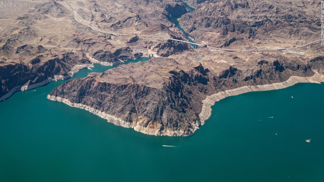
The reservoirs along the river system have been constructed as a buffer to store water and to ensure a reliable supply even in times of drought. But experts say that due to climate change and a 20-year drought, more water is now being extracted from the river system than flows into it, causing levels in these important reservoirs to drop.
“This shows us that the kinds of dire scenarios that we have been preparing for and hope will not happen are now here,” said John Fleck, the director of the University of New Mexico’s Water Resources Program.

“The study, while important, is no surprise,” the statement read. “We are prepared for these conditions, in large part thanks to Arizona’s unique collaborative efforts between water leaders, including tribes, cities, agriculture, industry and environmental organizations, who have developed innovative conservation and mitigation programs as part of the implementation of the Drought Contingency Plan.”
One of the farmers standing to see its water supplies diminish is Dan Thelander. Together with his son, brother and cousin, Thelander grows cotton, alfalfa and other crops on 6,500 acres in the desert of Pinal County, Arizona.
With less water expected to be available to him next year, Thelander said he will likely have to set aside 30 to 40% of his land or leave it undeveloped.

“We will have to fire workers. We will not buy that many seeds or fertilizers or tractors, and so we will just have to downsize and run a smaller farm,” Thelander said. “And yes, it will hurt a lot.”
Many farmers in Central Arizona, such as Thelander, have known for years that their supply of water from the Colorado River would eventually be phased out.
But with Lake Mead’s water level still near record lows and expected to decline further, the supply of that water could end years earlier than farmers expected.
Many factors contribute to the dwindling supply of the Colorado River system.
First, experts say more water is diverted from the river than enters the system.

“It’s a math problem – Lake Mead normally releases 10.2 million acre-feet of water per year, and 9 million acre-feet flows into it,” said Brad Udall, a senior water and climate researcher at Colorado State University. “At some point, because you have a 1.2 million acre foot deficit every year, you have to fix it or else you’re draining the reservoir.”
In addition to that structural deficit, a historic drought and climate change are also undermining the river’s supply.
Much of the Colorado River Basin has fallen under the spell of what some scientists have called a megadrought over the past two decades.
Most of the river’s flow comes from snow falling high in the Rocky Mountains of Colorado and southern Wyoming, said Chris Milly, a research hydrologist with the US Geological Survey and a co-author on the study.
Warming temperatures lead to a decrease in snowfall and an earlier melting of snow. But the sooner the snow melts and leaves bare ground, more heat energy from the sun is absorbed by the exposed soil. The warmer soil leads to more evaporation, which means less runoff from melting snow gets into the river, Milly said.
“Evaporation causes the catchment area to cool itself,” said Milly. “And so if you have more evaporation, you have less water to go down the river.”
Current conditions also don’t look promising for the kind of above-average runoff needed this year to start replenishing the river’s major reservoirs.
After an exceptionally hot and dry 2020, precipitation remained well below normal for much of the basin.
According to Paul Miller, a service coordination hydrologist at the National Oceanic and Atmospheric Administration’s (NOAA) Colorado Basin River Forecast Center, soil moisture in the region is also among the lowest on record.
This means that much of the melting snow carried off during the summer is likely to be absorbed by thirsty soils and plants before it can even reach the river, Miller said.
To Fleck, all this suggests that the diminished flows in recent years are likely not an anomaly, but rather a glimpse of the challenges of a warmer, drier climate.
“We now see the model for what the future of Colorado River Basin’s water use looks like, where scarcity is the norm and drought is not something special in the short term,” he said. “This is the way of life we are in now, as climate change diminishes the flow on the river.”